Most Popular
-
1
Korea’s homegrown nanosatellite successfully launches into space

-
2
[Herald Interview] 'Amid aging population, Korea to invite more young professionals from overseas'
![[Herald Interview] 'Amid aging population, Korea to invite more young professionals from overseas'](//res.heraldm.com/phpwas/restmb_idxmake.php?idx=644&simg=/content/image/2024/04/24/20240424050844_0.jpg&u=20240424200058)
-
3
Nicaragua shuts down Seoul embassy

-
4
Hybe's multilabel system tested amid conflict with Ador

-
5
Rocket engine expert, ex-NASA exec to lead Korea's new space agency


![[Herald Interview] 'Amid aging population, Korea to invite more young professionals from overseas'](http://res.heraldm.com/phpwas/restmb_idxmake.php?idx=644&simg=/content/image/2024/04/24/20240424050844_0.jpg&u=20240424200058)


-
6
SNU profs to suspend treatment for one day
-
7
SK hynix pledges W20tr to ramp up DRAM production at home

-
8
Over-50s, men, single-person households take up majority of those filing for bankruptcy

-
9
Pianist Cho Seong-Jin named Berlin Philharmonic's artist-in-residence

-
10
Ministry denies blame for Jamboree debacle


Google shows Jeju’s natural wonders
Search giant’s cultural platform seeks to give historic archive access to all
By Park Hyung-kiPublished : Oct. 30, 2014 - 21:28
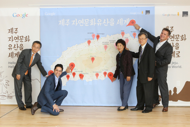
JEJUDO ISLAND ― Google has launched an online exhibition featuring high-resolution photographs of the volcanic island Jejudo’s cultural arts and archeological landscapes on the Google Cultural Institute platform.
The search giant said Thursday that the nonprofit arts platform has included gigapixel-grade panoramic photos of Jejudo’s UNESCO-designated natural wonders such as the Geomunoreum Lava Tube System and the Seongsan Ilchulbong tuff cone.
It has also digitized the cultural photo archives of “haenyeo,” or sea women, who dive underwater to harvest seafood, in partnership with the Jejudo government and its museums.
Google said the island’s project was launched not only to promote Jejudo’s culture and arts, but also to make them accessible to anyone in the world, in line with the portal’s long-standing commitment to democratize information.
“There are stories, not just photos that provide insights into these artifacts,” said Amit Sood, director of the Google Cultural Institute, at a launch event here.
“It does not matter if you are a student in Africa studying arts. We aim to bring access to everyone and make it interesting and fun through technology.”
The institute’s albums of thousands of free photographic archives, which can be explored virtually in 3-D, were made possible by the company’s Google Map and Street View mapping and camera technologies.
Google’s engineers and photographers used the Trekker ― a smart backpack, equipped with 2 terabytes of solid-state storage, and 15 small cameras on top that can shoot 360 degrees while hiking or walking ― to capture the island’s historic sites.
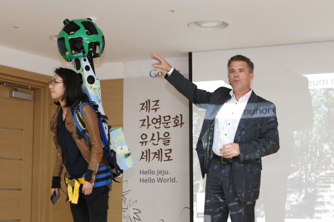
“How do I find a parking spot? Where is the entrance? We seek to provide practical information, allowing anyone to access, open imageries and answer all those questions,” said Ulf Spitzer, global program manager of Google Maps and Street View.
Spitzer said Google will go beyond the roads and streets to the ocean floor, which is accessible to very few people, and make the undersea visible to all, noting that Trekker cameras can be mounted on various equipment.
Launched in 2011, the cultural platform currently works with over 500 partners such as cultural heritage organizations, museums and archeological societies from 60 countries to digitally preserve artifacts and archives for future generations.
Google said it would continue to work with South Korea to digitally capture and show the culture and arts of Jejudo and other regions to the world.
By Park Hyong-ki (hkp@heraldcorp.com)


![[KH Explains] Korean shipbuilding stocks rally: Real growth or bubble?](http://res.heraldm.com/phpwas/restmb_idxmake.php?idx=652&simg=/content/image/2024/04/25/20240425050656_0.jpg&u=)